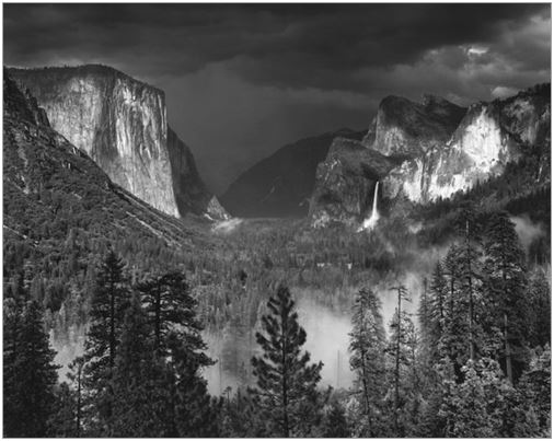
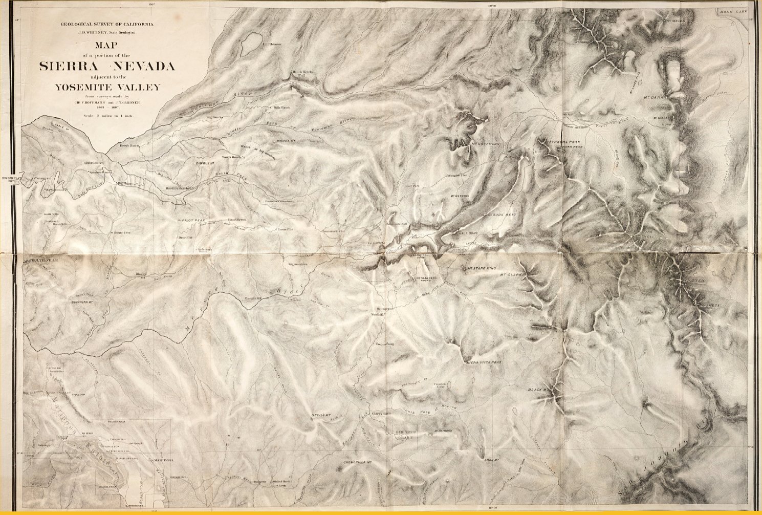
You might mine this question for further info. The question is about the John Muir trail which passes through some of the most beautiful parts of Yosemite. Muir got his first glimpse of this beautiful place in 1869 and spent the rest of his life—it was love at first sight. Along with people like early photographers Ansel Adams (his work) and Imogen Cunningham (her work) and many other California artists and writers, he almost immediately began working toward the protection the area from development. HERE is an 1887 topographic map of the Yosemite. By 1910, there were already taverns, pool halls, a bowling alley, a golf course, vacation homes and ranches on large parcels of privately held land in the valleys and mountainsides in and surrounding Yosemite Valley and Kings Canyon.
In 1903, Muir somehow got the President of the United States, Theodore Roosevelt to spend three nights under the stars with him and naturalist John Burroughs in Yosemite. He took city-boy Teddy—who stated that he’d never, in any of his travels, seen such majesty before—to the top of the world, showed him the magnificent thousand year-old redwoods that were being threatened by wanton harvesting. Teddy, evidently, was suitably impressed. Building restrictions, land purchase restrictions and official state preservation efforts began the following year. The result was the protective inclusion of Yosemite into our National Park system in 1940. Today, Muir’s name is all over California, most prominently in Yosemite.
We owe the existence of an undeveloped Yosemite and Kings Canyon National Parks to these activist artists and writers. For those in doubt of this, a comparison of Muir’s descriptions from his 1869–71 journal, published in 1911, and today’s Yosemite will show little change. The Muir journals are now on the net as free downloads from Project Gutenberg:
My First Summer in the Sierras and The Mountains of California. Both of these books descriptions of trails in Yosemite and nearby King’s Canyon easily searchable by name by using your wordsearch. Large parts of My First Summer in the Sierras is especially pertinent to Yosemite and, if you have the time, well-worth a quick scan before you set off. Current material is all over the net, including individual Yosemite camping and hiking diaries from this decade.
There are complete, current, detailed topographic maps along with elevation profiles, estimated hiking times, point-to-point distances, on-trail resources, prep advice, etc. of all parts of the John Muir Trail (JMT) and other trails, in day-trip sections, including those portions that traverse Yosemite from the Stanislaus National Forest at the northern border of Yosemite south to Yosemite Valley, then northwest to Tuolumne Meadows in the Amsel Adams Wilderness.. But it is much easier terms of supply and transportation to start at Yosemite Village in Yosemite Valley and head west-south-west on the John Muir Trail to Toulumne Meadows at the western end of the park.
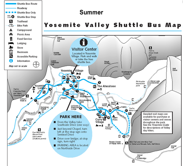
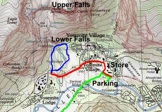
At Yosemite Village there is every convenience, including a shuttle bus from Yosemite Village that will take you and your equipment from the Village Parking Lot to your chosen embarkation point in Yosemite Valley.
I push the JMT because it rides the Sierra ridge which will guarantee the most heart-stopping vistas—an appropriate reward for the hard work of getting there—and there is tons of detailed material on the net concerning every aspect of this trail.
From This and This and the topos you can pick out your destination by determining the view you will have at the top and use the name of your destination to pull up the trail topo and elevation profile on google. I use google images and the resultant photos to access the relevant material. Also, once you have the name of the trails you are considering, you can then access the diaries by googling “Name of trail”+diary (or journal, or daybook).
If you choose the Yosemite portion of the JMT, I highly recommend the most current John Muir Trail Atlas pocket edition to take along with you and keep notes on your daily progress. It is packed with detailed maps and info and, although you will only use the Yosemite portion, it is a most interesting piece of literature and a good souvenir of your trip.
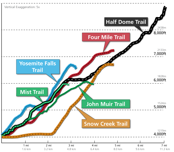
Topographic maps of Yosemite Trails HERE. What you learn from this is that there are many different trails requiring different levels of exertion and expertise. There is the less challenging 4 Mile Trail day-hike around the rim of Yosemite Valley, and there is the more difficult, longer JMT to Tuolumne, or shorter sections thereof. By scanning these maps and elevation profiles, you also learn the names and difficulty of these trails in order to research further the more interesting ones depending upon your allotted time and the physical demand. Even the shortest trail can be a challenge.
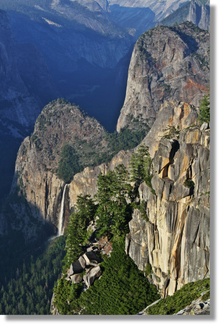
I took this trail, with my father and big brother in 1964 when I was 11. Only 3 miles, dad said. No sweat, we said. What my brother and I didn’t know was that we were about to climb 3,000 ft. in the next couple of hours following a 6’4” ex-Marine with extremely long legs and no mercy, who intended this to be some kind of rite of passage for the two of us.
My brother and I both made it to the top, with my father in the lead, and learned from him to help each other in our mutual struggle along those incredibly endless switchbacks—we two dedicated rivals—and the exhilaration as we looked down upon Yosemite Falls from Yosemite Point and what seemed to be all of California and Nevada from nearly 7,000 feet was a near spiritual experience and I remember it like yesterday 52 years later. I’ve since climbed Rainier complete with rope and pitons, and been caught on the sides of Norwegian fjords in bad weather, but this was my first victory. Everybody who has done something seemingly as insurmountable as this seemed to a surburban, eleven year old who’d rarely been out of the San Joaquin Valley, remembers their first victory.
This is what that trail looks like today. Trust me, in 1964 it wasn’t nearly as well manicured and well defined.
A description of the John Muir Trail Overview (Including Yosemite Section) HERE
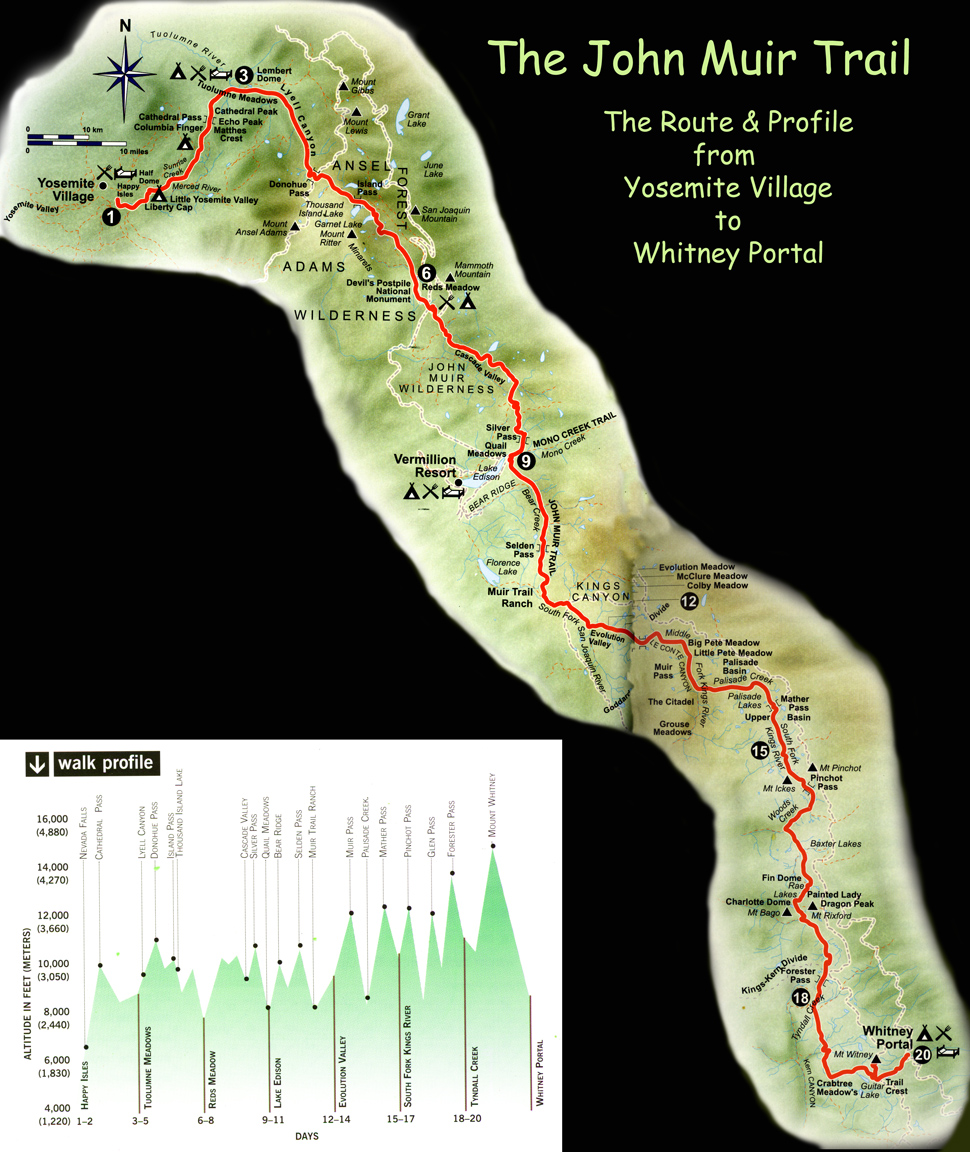
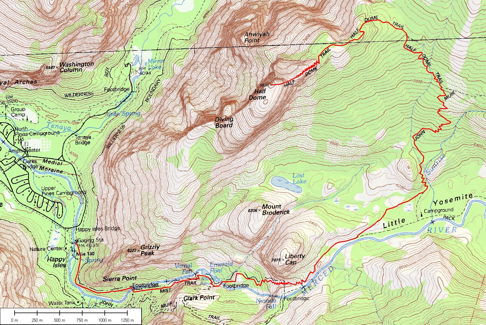
John Muir Trail elevation overview HERE. HERE’S another, simpler map of the JMT. In this last map, your interest is at the top northernmost portion of the map, from Happy Isles to Lambert Dome, or point 1 to 3. From this, you will see that the Yosemite portion of the JMT is from Yosemite Valley to Tuolumne Meadows at the Tuolumne River and Lambert Dome. You can look up and get topos, elevation profiles, hiker diaries and National Park info on any portion of this trail on the net—usually for free.
This is a typical journal describing the Yosemite section of the JMT from Tuolumne Medows southeast to Yosemite Village in Yosemite Valley. It took the guy and his seven friends 5 days and 4 nights to cover the 32.5 miles. The reason he started at Tuolumne and not at the Village is because he prefers descent to ascent. The Tuolumne embakation required only a total of 5,000 feet of ascent afterwhich he enjoyed 9,000 ft. of descent at the end of his hike. Makes sense to me. In this diary he provides hotlinks to each day of his journal. This is what it looks like at the 9,300 ft. summit of Sunrise Peak before the final descent into Yosemite Valley on this portion of the JMT. These diaries are invaluable to hikers unfamiliar to the territory. And Check this out
HERE’S some National Park info on this portion of the JMT. You need a permit. The money helps maintain and protect this pristine trail in the most populated state in the nation.
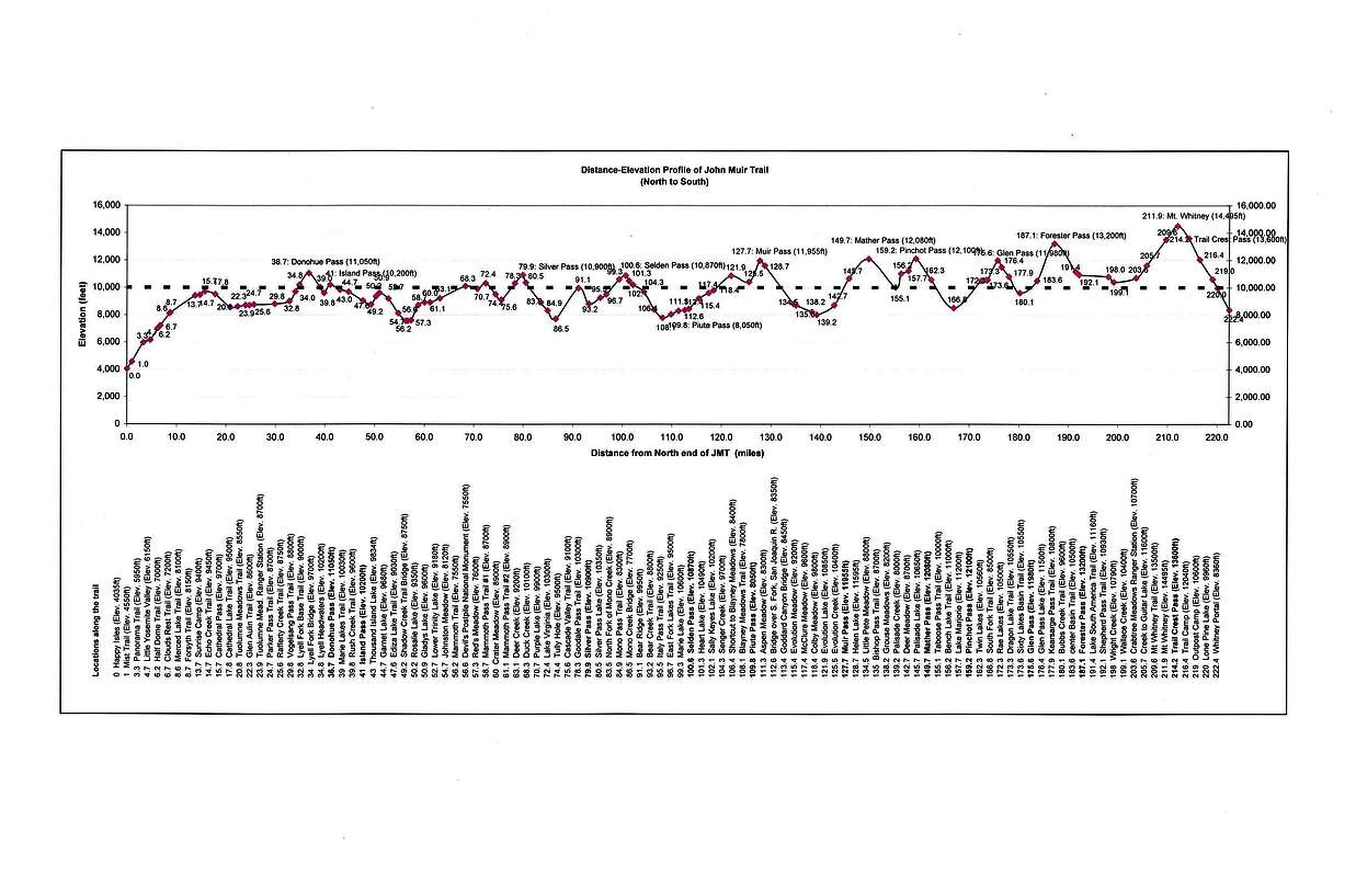
The complete 120 mile John Muir Trail Elevation Profile is HERE. You can highlight the section that traverses the Yosemite National Park. This will give you an excellent idea of the amazing views you will have along the Trail—and the difficulty you might have getting to them. But you don’t see stuff like that from the ground floor of a high valley.
OTHER Yosemite Trails:
Comparative elevation profiles of the short, day hikes that start from Yosemite Village.
The short, less challenging Valley Loop
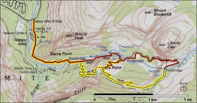
The entrance to the JMT from the Village at the southwest end of the parking lot leading to Happy Isles across the footbridge and on to the very short loops to Vernal and Nevada Falls. Remember: the easier, shorter and closer to the Village the hike, the more crowded the trail may be.
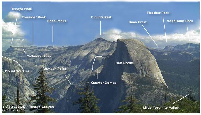
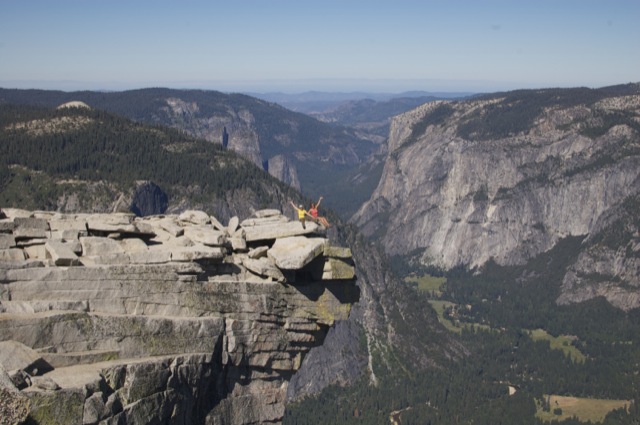
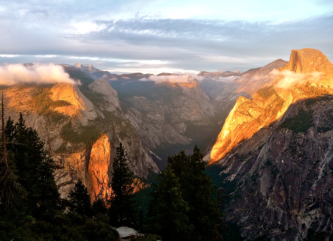
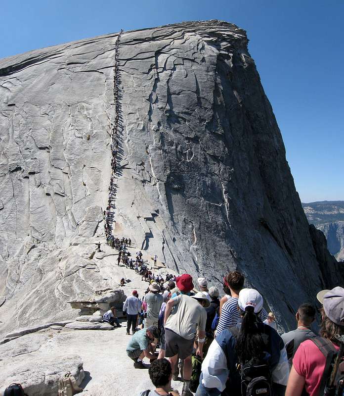
“Half Dome”: is undeniably beautiful and majestic and the hike, although challenging, is understandably crowded, especially at the top where many people lose their resolve and things can get backed up. The Half Dome Hike from the Village to the top of Half Dome is probably the most popular hike in Yosemite due to it’s proximity to the the Village, it’s short distance (approx. 15 mile round trip) and the views it promises at 8,000 feet while gazing 4,000 feet into the valley below. It really dose feel like you’re on top of the world. It’s no walk in the park, though, and even getting down can be traumatic for some people. It requires an ascent of nearly 5,000 feet, the last 400 ft. ascent is almost straight up. But if all you have is a day, then this is probably the unforgettable hike for you.
The Half Dome Hike is aprox. 15 miles, 7–12 hours, depending on your physical condition. Permits are issued via lottery, so apply in good time before your arrival.
Half Dome the easy way
The Half-Dome Hike in 3D. Follow the yellow line.
Another map of the Half-Dome Hike map. The Village parking lots and hotels are in the upper left.
A very good Half Dome Hike Map. Click to enlarge for detail.
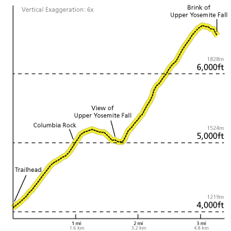
Half Dome Elevation Profile
Photo essay on the Half Dome Hike complete with amateur photos. Check out the weight the lady in the last few photos was carrying with her. Amazing. She made it. That must have been one helluva hike for her.
The Cathedral Lakes trail to Tuolumne Meadows
“Cathedral Lakes to Tuolumne Meadows Elevation Profile”:
A description of the 33 mile Ansel Adams Wilderness Backpacking Loop
Christ, this has become so long that it will take you between now and your trip to read the damn thing. Sorry. There is so much info here that you don’t even have to go now. I’ll send you my bill.
Good luck and happy trails. I am positive that no matter which trail you choose, you will come out the other end quite satisfied and with a very interesting story to tell. I wish I could join you. I love this part of California. Nothing makes me more homesick for my country, an almost impossible feat. Please be sure to tells us all about your hike when it’s over, will you?


 )“Great Answer”
(3
)“Great Answer”
(3